
TERRANIS
31 -
With Landia, create a portrait of your territory
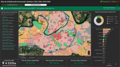
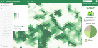
To meet the needs of communities regarding territorial planning and sustainable development, TerraNIS developed the Landia solution. More than just a technical mapping tool, Landia is a diagnostic, analysis, evaluation, and decision support tool for managing your territories. We approach the topic of planning from various angles:
- Urban Vegetation
- Urban Climatology
- Soil Sealing
- Natural, Agricultural, and Forest Areas
Municipalities, administration, land planners, consulting firms, or experts, discover how Landia can help you design and manage the territory of tomorrow.
- Biodiversity and protection of wildlands: woodland, coastline, mountains, landscapes and gardens
Products / Projects
Landia
Cartovégétation
Learn more
GDPR
Business name : TERRANIS SASCommercial Register : 80081536700035